This east-to-west driving tour of the Columbia River in Washington focuses on state and national parks and wildlife areas. It was written and curated by HistoryLink senior historian Cassandra Tate, and many of the photographs were taken by historian Glenn Drosendahl for HistoryLink. The tour was made possible by a grant from the Peach Foundation and an appropriation by the Washington State Legislature.
A River of the Imagination
The Columbia is as much a river of the imagination as it is of hydraulics. It existed as an idea -- among people living far from its actual shores -- long before cartographers began drawing its actual contours on maps. Seventeenth-century European geographers envisioned it as the "River of the West," a longed-for shortcut to the riches of the East. Eighteenth-century explorers searched for the headwaters of the "Ouragon" in the mythical Straits of Anian, said to be a "Northwest Passage" to the sea. Nineteenth-century entrepreneurs knew there was no Northwest Passage, but they dreamed of other wealth that could be harvested from the river. Twentieth-century engineers looked at the river and saw unlimited kilowatts, millions of acres of irrigated desert, and a watery highway that would turn landlocked cities into seaports.
The great river has carried many different names. To the Chinookan people who lived along its lower banks it was "Wimahl," meaning simply "the big river." The Sahaptin speakers on the upper river called it "nc' i-wána." The Spanish explorer who was the first non-Native to actually see the river, in 1775, named it the "San Roque." Seventeen years later, an American merchant seaman gave it the name it bears today, after his ship, the Columbia Rediviva.
Originating as melting snow in the mountains of British Columbia, the Columbia gathers water and energy from dozens of tributaries in its 1,214-mile journey to the sea. The second-largest river in North America, it touches the lives of nearly everyone living in the Pacific Northwest. It is a corridor for commerce and transportation; a source of food, electricity, and water for irrigation; a conduit for industrial, agricultural, and municipal wastes; the unifying force that knits the Northwest into a tapestry of mountains, deserts, river valleys, grasslands, gorges, and forests.
The Columbia is the most engineered river in the world. There are more than 400 power and irrigation dams on the river and its tributaries, including 11 on the main stem in Washington alone. From Bonneville Dam, near the mouth of the river, to Donald Station, in Canada, the Columbia is essentially a series of calm lakes behind concrete barricades, named after dead leaders or buried landmarks.
The environmental costs have been huge. Natural runs of salmon and steelhead have all but disappeared, replaced by welfare fish, raised in hatcheries and barged around dams. Releases of radioactivity from the Hanford Nuclear Reservation, seepage of pesticides from farm fields, erosion caused by logging, discharges of heavy metals from smelters and other industries: All these have ecologically burdened the Columbia.
And yet natural wonders can still be found along the river. According to one estimate, irrigation runoff has [in 2006] increased the overall acreage of wetlands in the Columbia Basin by a factor of 20, creating enticing stopovers for migrating birds and waterfowl in areas they used to bypass entirely. Cold War secrecy helped preserve the Hanford Reach, the only remaining free-flowing, nontidal stretch of the river, now part of the 195,000-acre Hanford Reach National Monument. Twenty-two Washington state parks are located on or near the main stem of the Columbia, in addition to 16 national wildlife refuges, scenic areas, and recreation areas.
After more than a century of dredging, channeling, pumping, and damming, the Columbia remains "an organic machine" (in the words of historian Richard White), serving a thousand masters yet retaining a life of its own.
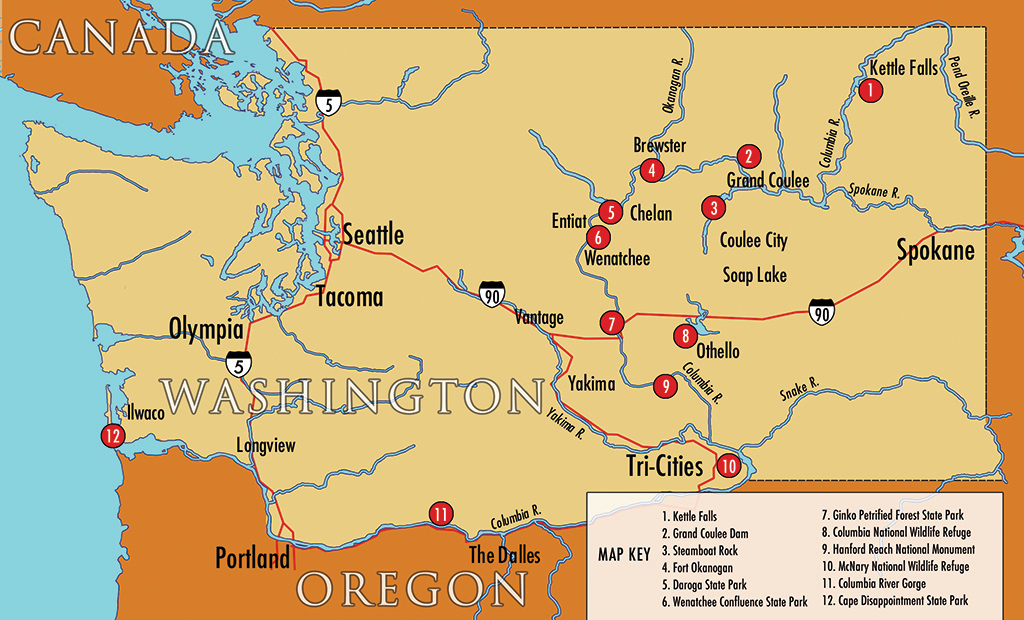
The following tour stops are numbered to correspond with the map above:
1. Kettle Falls, on the upper Columbia about 40 miles south of the Canadian border, was once one of the most important fishing and gathering places for Native Americans in the Northwest. Salish speakers called it Shonitkwu, meaning roaring or noisy waters. The sound of the river, plunging nearly 50 feet in a series of cascades, could be heard for miles. It was said that the salmon ran so thick here that it was impossible to throw a stick into the water without hitting a fish. All this came to an end in 1941, with the completion of Grand Coulee Dam, located about 100 miles downstream. The dam, built without a passage for fish, closed the upper Columbia and its tributaries to migrating salmon. Today, the noise at Kettle Falls comes not from rushing water but from nearby Highway 395. The falls themselves are just slabs of quartzite, buried deep beneath the surface of a reservoir called Franklin D. Roosevelt Lake.
2. Grand Coulee Dam, hailed as the "Eighth Wonder of the World" when it was completed in 1941, is as confounding to the human eye as an elephant might be to an ant. It girdles the Columbia River with 12 million cubic yards of concrete, stacked one mile wide and as tall as a 46-story building, backing up a 150-mile long reservoir, spinning out more kilowatts than any other dam in the United States. As gargantuan as it is, Grand Coulee is only part of the massive Columbia Basin Project, which includes four other dams, three storage lakes, and 2,300 miles of irrigation canals, snaking through half a million acres of desert. No other public works project has had a greater impact on the development of the Pacific Northwest. The social and environmental costs have been so severe, according to a study released in 2000, that Grand Coulee probably could not be built today.
3. With a surface area of 600 acres, Steamboat Rock is something more than a rock. A massive basalt butte, several miles long and 800 feet high, it looms like a battleship above Banks Lake, a manmade reservoir that fills the upper Grand Coulee in northeastern Washington. Steamboat Rock is the dominant feature in one of Washington’s most popular state parks. It is also a key stopping point on a proposed Ice Age Floods National Geologic Trail, a network of sites in Montana, Idaho, Oregon, and Washington, each bearing the dramatic imprint of the cataclysmic floods that swept across the region thousands of years ago.
4. Fort Okanogan was the first American outpost in what is now Washington. Established in 1811 by representatives of John Jacob Astor’s Pacific Fur Company, the "fort" was a modest affair, initially consisting of only one small building at the confluence of the Okanogan and Columbia Rivers. The Canadian North West Company acquired it in 1814, expanded it, and later sold it to the British Hudson’s Bay Company. The British replaced the complex with a second one, built about a mile away, in the 1830s. Today a small state park overlooks the second location. Only the wind and a simple highway historical sign mark the site of the original Fort Okanogan, which proved to be a temporary beachhead in an area that would not become part of the United States for 35 years.
5. Daroga State Park, on the east bank of the Columbia in North Central Washington, was once part of an orchard and ranch operated by legendary fruit grower Grady Auvil, who introduced Red Haven peaches, Granny Smith apples, Rainier cherries, and many other new fruits to the Northwest. Auvil moved to higher ground in the late 1950s when the Chelan County Public Utility District (PUD) began building Rocky Reach Dam. The reservoir behind the dam, called Lake Entiat, inundated part of the original orchard. The PUD bought the rest in 1981, developed it as a park, and leased it to the state. The park is an incongruous oasis of deeply watered lawns and full-service campsites, bisected by several huge, high-voltage transmission towers, painted bright orange and white. Kite flying is strictly prohibited because of the network of power lines overhead, humming with electricity from the dam that turned this section of the once-muscular Columbia into a well-mannered lake.
6. Located at the confluence of the Wenatchee and Columbia Rivers, in almost the exact center of Washington, Wenatchee Confluence State Park is a study in dichotomies. The north side is a manicured haven for people who like to camp in comfort. The southern half is a manmade "natural" area, a former orchard and cattle pasture that has been bulldozed back into wetlands. The line of demarcation is the Wenatchee River, still muscled by enough rapids to be popular with river rafters upstream, merging with the reservoired Columbia on the eastern edge of the park. Three major highways converge nearby in a busy interchange lined with warehouses and big-box stores. The hum from the highways has replaced the roar once made by rapids at this point, but the voice of nature can still be heard, in the calls of birds and the sound of wind rustling through the leaves of stately old cottonwoods.
7. Ginkgo Petrified Forest State Park contains the remains of one of the most unusual fossil forests in the world. It was set aside as a historic preserve in the 1930s, after highway construction crews working on the Vantage Road unearthed what proved to be some of the rarest forms of petrified wood ever found. Located one mile north of Vantage, near the geographic center of Washington, the park is now a registered national natural landmark.
8. The Columbia Basin Irrigation Project did more than turn half a million acres of arid Eastern Washington into lush farmland. It also created an enticing stopover for millions of migrating birds. Land once dominated by sagebrush and dust now sparkles with reservoirs. Seepage from canals and pipes has given rise to marshes, bogs, and ponds. Drainage ditches, designed to carry excess water from farm fields, function as creeks in a landscape redesigned by hydraulics. These manufactured lakes and artificial wetlands form the heart of the Columbia National Wildlife Refuge, a 23,000-acre haven for more than 200 species of birds and waterfowl, including many that previously bypassed the region entirely.
9. The Hanford Reach National Monument -- one of the most important wildlife refuges in the state -- is an inadvertent legacy of the United States' nuclear weapons program. Lands within the monument originally served as a buffer around the Hanford Nuclear Site. For nearly half a century, Hanford was the primary source of plutonium for the nation's nuclear arsenal. The need for secrecy and security kept the surrounding area free from development. Wildlife flourished, even in the shadows of the reactors that produced, along with plutonium, some of the most toxic waste in the world. The reservation itself is undergoing the most complicated and costly cleanup in history. But it is encircled by an ecological treasure trove, including the last free-flowing stretch of the Columbia River, the most valuable salmon spawning grounds left on the river, and the largest remnant of undisturbed shrub-steppe habitat in Eastern Washington.
10. The McNary National Wildlife Refuge, on the east bank of the Columbia near its confluence with the Snake River, was established in 1954 in an effort to compensate for the loss of wildlife habitat due to the construction of McNary Dam. With nearly 16,000 acres of marshes, mudflats, and shrub-steppe uplands, the refuge has become an important feeding and resting area for migratory birds and waterfowl. Its bays and shorelines serve as nurseries and passageways to spawning grounds for endangered steelhead, sockeye, and Chinook salmon. However, like other wildlife preserves on the mid-Columbia, McNary has proven to be a better haven for avian life than for fisheries. One of the many threats facing the river’s fish stocks today is the increasing population of American white pelicans and other predators, which flourish in areas where they were once uncommon, drawn by McNary and other refuges.
11. The Columbia River Gorge is a symphony of water and rock, a 90-mile-long passageway sliced through the Cascade Range by a river on its way to the sea. The mountains divide the Pacific Northwest into two dramatically different regions; the Gorge is a link that brings them together. On the eastern end are the treeless, scorch-colored hills of the arid Columbia Basin. To the west lie mossy forests of spruce and fir, set off by basalt cliffs ribboned with waterfalls. Congress paid tribute to the Gorge's natural beauty by designating it a National Scenic Area in 1986. But the Gorge is more than just scenery. Native Americans gathered here to fish, trade, and socialize for thousands of years. The Northwest's first railway, first system of locks, and first modern highway were all built in or near the Gorge. Today the area is a laboratory for an experiment in public policy, with the federal government, two states, six counties, dozens of communities, and scores of special interest groups involved in a delicate dance to balance environmental protection and economic development.
12. Cape Disappointment State Park juts into the Pacific Ocean at the tip of the Long Beach Peninsula, in the southwesternmost corner of Washington. This is the place where Lewis and Clark and the Corps of Volunteers for Northwestern Discovery ended their long journey to the sea. They carved their names and the date -- November 18, 1805 -- on a tree, pausing to watch the powerful surf breaking on the rocks below. Exactly 200 years later, members of the Chinook Tribe, art patrons, politicians, and community leaders gathered here to dedicate the first phase of the Confluence Project, designed by famed artist and architect Maya Lin to commemorate the Lewis-Clark Expedition. For Lin, Cape Disappointment is a study in convergence: water and land, river and ocean, white explorers and Native Americans, past and present. "Here is where we hold up a mirror to the Lewis and Clark story," she says. "Our journey begins here."
